How to anchor without damaging seagrass
Learn how to identify a safe sand patch, allow for the full swinging circle, set and recover the anchor vertically, and verify the local rules protecting seagrass.
In brief
To avoid damaging seagrass, check local restrictions and habitat maps first, use an authorised mooring when available, and anchor only on bare sand large enough for the rode and full swing. Lower the anchor under control, set it gently, monitor for dragging, and bring the boat directly above it before retrieval. If the bottom is unclear, relocate.
Article outline
A pale patch of sand is more than a convenient target for the anchor: it keeps the flukes and rode away from living seagrass. Responsible anchoring starts before the bow reaches the bay, because habitat maps, local rules, water depth and the vessel's full swinging circle all have to agree. When they do not, an authorised mooring or another anchorage is the sounder choice.
Treat a seagrass meadow as a no-contact area
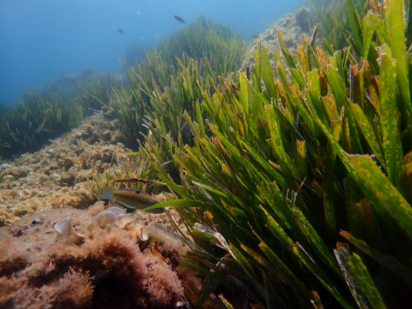
Seagrasses are flowering marine plants rather than seaweeds. In the Mediterranean, Posidonia oceanica builds extensive meadows that shelter marine life and stabilise coastal sediment; the European Union lists Posidonia beds as a priority habitat under the Habitats Directive.
An anchor does not affect only the spot where it lands. Its flukes can cut into roots and rhizomes, while a chain lying on the bottom can sweep a broad arc as wind or current turns the boat. Dragging the gear during retrieval adds another path of abrasion, so simply aiming the anchor at a gap is insufficient if the gap cannot also contain the rode.
The principle travels beyond one species or region. NOAA's guidance for sanctuary visitors tells boaters to use a mooring where one exists and, otherwise, anchor on sand or mud well clear of coral, seagrass and underwater cultural resources. The local habitat and law may differ, but avoiding contact is a durable operating rule.
Build the plan from charts, notices and boat geometry
Planning begins with current official charts and the notices issued by the harbour authority or protected-area manager. Habitat layers and environmental apps can reveal likely meadow boundaries or low-impact moorings, but they are planning aids; they do not supersede navigation charts, buoyage or a binding local order.
The crew should identify a primary site, an escape route and an alternative before arrival. Depth must be sufficient for the vessel's draught through the expected water-level range, and the approach should avoid shallow vegetation. NOAA specifically advises using marked channels and knowing how much water the hull and propeller require.
The relevant footprint is the complete swinging area. A sand hole that accepts an anchor may still be too small once depth, bow height, scope, wind shifts and current reversals are considered. Other boats, rocks, bathing zones and the room required to weigh anchor belong in the same calculation; ecological care cannot come at the cost of collision or grounding risk.
Read the bottom, then verify the target
In clear water and useful light, bare sand is commonly pale and even, whereas a meadow looks darker and textured. Polarised glasses and a lookout at the bow can make the boundary easier to follow. French biodiversity guidance describes sandy areas as generally lighter, but “generally” matters: cloud, glare, algae, suspended sediment and depth can reverse or blur the visual cue.
Depth sounders and imaging sonar may support the observation, especially when crossing a sharp edge. They do not turn an uncertain return into permission to drop. If the crew cannot identify a bare patch large enough for the anchor and all bottom-contacting rode, the correct response is to abort and reassess.
Looking from the surface is preferable to improvising a swim. A competent person may inspect the bottom in suitable, controlled conditions, but current, traffic, cold water and propellers can make that option unsafe. No habitat-protection objective justifies putting a crew member into an unmanaged hazard; moving to a clearer site is often quicker and safer.
Lower, set and monitor with minimal seabed movement
Stop the vessel over the selected target and lower the anchor under control until it reaches bottom. Throwing it overboard sacrifices accuracy and may carry the flukes into the edge of the meadow. Pay out the planned rode while the boat moves astern slowly, keeping the lead aligned rather than piling chain onto one spot.
Set the anchor progressively and confirm that the vessel has stopped moving over the ground. Shore transits, a plotter trail and the feel of the rode provide complementary evidence. Slow, controlled astern power also leaves time to stop the test if the anchor fails to bite or if the vessel approaches vegetation.
Monitoring continues after the engine is off. A correctly configured anchor alarm can reveal movement, but its result depends on GNSS accuracy, alarm radius and where the position was recorded. If the anchor is dragging toward vegetation, recover it and relocate; paying out more chain without checking the new sweep can enlarge the affected area.
Break out the anchor from directly above
To weigh anchor, motor slowly toward it while taking in slack. The windlass is intended to recover the rode, not haul the boat bodily against wind or tide. When the bow is nearly above the anchor, the pull becomes more vertical and the flukes can break out with less travel across the seabed; the French biodiversity office explicitly recommends this positioning.
If the anchor remains stuck, pause before increasing load. Reconstruct how it was set, control the boat and try a careful change of pull from above or just beyond the set direction. A trip line can be valuable on an appropriate bottom, but it also creates another line and float in the water, so it needs deliberate rigging and must not be mistaken for a public mooring.
Vegetation brought aboard is evidence that the operation contacted the meadow. It should trigger a change of site and technique, not another attempt in the same patch. After an accidental grounding, NOAA advises stopping immediately rather than powering off, because propeller wash and hull movement can deepen damage; the skipper should then follow the local reporting or assistance procedure.
Check the rule that applies to this exact bay
Habitat status at European level does not create one identical anchoring rule for every Mediterranean coast. Restrictions can depend on country, protected area, vessel length, season and coordinates. Buoys, harbour notices and current orders therefore outrank a skipper's recollection of what was allowed on an earlier visit.
France has protected Posidonia as a species since 1988 and uses Mediterranean maritime orders to manage anchoring in specified areas. The French interregional maritime authority directs users to the Préfecture maritime de la Méditerranée for the decrees currently in force. Spain's Royal Decree 191/2026 establishes a common protection framework for Mediterranean seagrass meadows and regulates vessel anchoring over them, while regional and site-level instructions still need to be checked.
A reliable departure brief is short: verify the legal layer, prefer an authorised low-impact mooring, choose a sand area large enough for the whole swing, lower rather than throw the anchor, watch for dragging and retrieve vertically. If the chart, the view through the water and the local notice do not tell the same story, treat the discrepancy as a reason not to anchor there.
Sources and references
Sources consulted and references retained to verify data and context.
- Les herbiers de posidoniesOffice français de la biodiversité
- Tips For Being a Responsible BoaterNOAA Office of National Marine Sanctuaries
- Las praderas de Posidonia y túJunta de Andalucía — LIFE Posidonia
- Regulations: anchoring and Posidonia in the French MediterraneanDirection interrégionale de la mer Méditerranée · 2024-11-12
- Fanerógamas marinasMinisterio para la Transición Ecológica y el Reto Demográfico
Continue reading
406 MHz EPIRB and PLB: choosing, registering and testing
September 27, 2026 · 7 min read
Navigation lights: inspect and test them aboard
September 26, 2026 · 7 min read
Boat reboarding ladders: test them from the water
September 25, 2026 · 7 min read