IALA buoyage: how to read lateral and cardinal marks
A reasoned guide to IALA Regions A and B, cardinal topmarks, colour bands and light rhythms—and to turning each observed mark into a verified track.
In brief
To read an IALA buoy, identify the mark family first. Lateral marks require the buoyage region and conventional direction; cardinal marks use compass direction, black-and-yellow bands, cone topmarks and white-light rhythms to show the safer side. Confirm at least two clues against an up-to-date chart, depths and notices, because a buoy may be unlit, damaged or displaced.
Article outline
A buoy is not a floating instruction to “go left” or “go right”. It first identifies the kind of information available: the edge of a channel, the safer side of a hazard, an isolated obstruction, or an area whose purpose is defined elsewhere. Sound use of the IALA buoyage system begins by classifying the mark, then deciding how it affects the planned track.
The dependable approach combines the current chart with buoyage direction, colour, body shape, topmark and light rhythm. Each clue can degrade or disappear, so the navigator should look for agreement between several clues rather than trust a single memorable colour rule.
Separate channel edges from compass directions
Lateral marks define the sides of a well-established channel. Their meaning is tied to the conventional direction of buoyage, which the competent authority sets and which commonly runs from seaward into a harbour or upstream. A red buoy has no complete passing instruction until both that direction and the applicable IALA region are known.
Cardinal marks answer a different question. They identify the side on which the safer or deeper water lies by reference to north, east, south or west. A north cardinal therefore directs attention to water north of the mark; it does not create a universal instruction to keep the buoy on one particular side of the boat.
That distinction is the first cockpit decision. For a lateral mark, establish the conventional direction and region. For a cardinal mark, convert its name into a compass side, then check whether the charted depth, sea room and intended track make that route suitable for the vessel.
Region A and Region B reverse lateral colours
IALA uses two regional colour conventions for lateral marks. In Region A, used around Europe, red denotes the port-hand side and green the starboard-hand side when travelling in the conventional direction. Region B, used in Canada and the Americas among other areas, reverses those colours: red is to starboard and green to port.
Shape offers a second recognition channel. A port-hand lateral mark is can-shaped or carries a cylindrical topmark; a starboard-hand mark is conical or carries an upward-pointing cone. The regional reversal concerns lateral colours. Cardinal, isolated-danger, safe-water, special and emergency-wreck conventions otherwise remain common across the system.
At a channel split, a modified lateral mark uses a band of the opposite colour to show the preferred channel. Preferred does not mean compulsory, nor does it guarantee adequate depth for a particular craft. Draft, local directions, temporary works and traffic can all affect the safe choice, so the charted channel and current notices remain authoritative context.
Decode a cardinal by topmark, bands and light
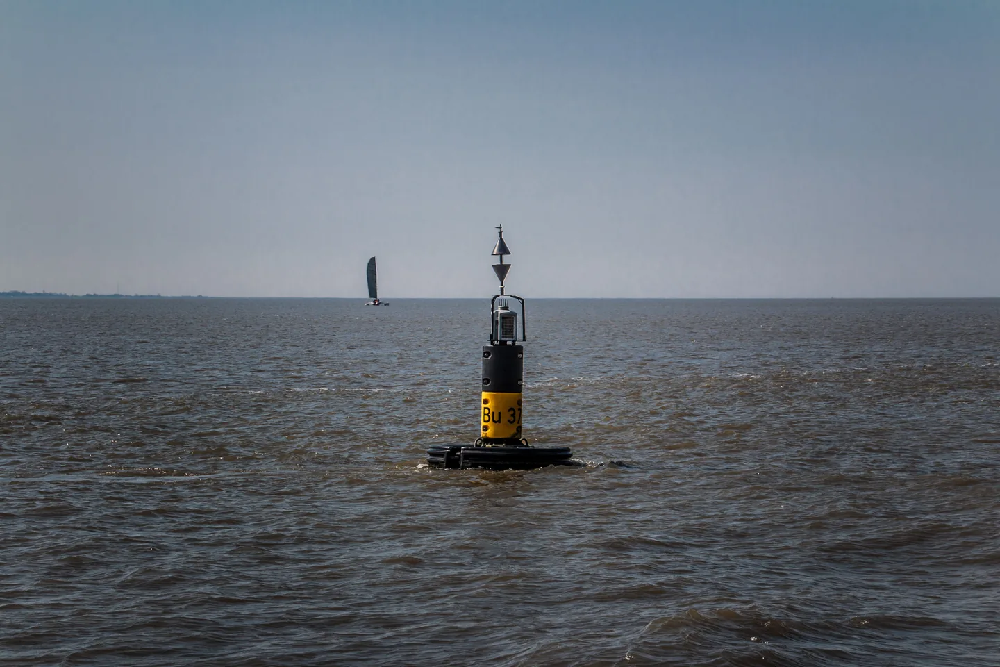
Cardinal marks are black and yellow and, when lighted, show a white light. Their two black cones provide the fastest daylight key: both point up for north, away from each other for east, both down for south, and towards each other for west. The cones also map the black paint—above, at both ends, below, or through the middle respectively.
| Mark | Cone arrangement | Colour bands | Characteristic white light |
|---|---|---|---|
| North | both points up | black over yellow | continuous Q or VQ |
| East | points apart | black-yellow-black | groups of 3 Q or VQ flashes |
| South | both points down | yellow over black | 6 Q or VQ flashes plus one long flash |
| West | points together | yellow-black-yellow | groups of 9 Q or VQ flashes |
At night the numbers follow the face of a clock: east is three, south six and west nine, while north continues quick or very-quick flashing without a numbered group. The extra long flash after south’s six distinguishes it from west when observation begins part-way through a sequence. Watch at least two complete cycles and compare the full period printed on the chart before settling on an identity.
A cardinal name describes the recommended side of the mark, not an unlimited safe sector. Water east of an east cardinal is the indicated passage, but its depth and width still have to be tested against the vessel’s draft and conditions. The mark supplements bathymetry and pilotage information; it does not erase them.
Recognise the marks that are neither lateral nor cardinal
An isolated-danger mark is black with one or more red horizontal bands and has two black balls as its topmark. It sits on or close to a limited hazard with navigable water around it. A safe-water mark has red and white vertical stripes and a single red sphere; it may identify mid-channel water, a landfall or water that is navigable all around.
A special mark is yellow and may carry a yellow X. Its meaning comes from the chart and associated nautical publication, because it can identify an area or feature rather than a standard passing side. The emergency wreck-marking buoy is vertically striped blue and yellow with an upright cross topmark, making a newly discovered wreck conspicuous while permanent marking and chart information catch up.
Light colour helps sort these families after dark. Laterals show red or green, cardinals, isolated-danger and safe-water marks use white, special marks use yellow, and the emergency wreck mark alternates blue and yellow. Since several marks share white, rhythm is not optional detail; it is part of the identity.
Turn identification into an early manoeuvre
Begin on the largest suitable-scale chart, before the buoy is abeam. Read the symbol, designation and advertised light characteristic, then decide whether it defines a channel edge or a safe side around a hazard. If it is lateral, confirm region and direction; if cardinal, translate the name into a compass-bearing side.
Seek two independent observations in agreement. Colour and shape, topmark and band pattern, or light colour and rhythm provide stronger identification than any clue alone. A mismatch between the observed mark and the chart is not something to average away: slow down, preserve sea room and reassess the vessel’s position before committing to the gap.
Plan a track past the mark rather than steering reflexively at close range. Account for charted depth, draft, tidal height, set, wind, turning room and opposing traffic, then choose an alteration point that clears the danger without occupying unnecessary channel width. This is Batoo’s procedural analysis, not a fixed clearance rule; IALA assigns no one distance that works for every hull, hazard and sea state.
The same discipline applies when travelling against the conventional direction. Lateral roles do not swap, but the boat’s perspective does: a mark previously kept to port may now be kept to starboard. Re-establishing direction aloud before an entrance or departure is a simple bridge habit that prevents a remembered slogan from overruling the chart.
Treat every buoy as fallible evidence
Navigation authorities explicitly warn against relying on buoys alone. A floating aid may be unlit, damaged, fouled or displaced by weather, ice, collision or equipment failure, and many are not watched continuously. Because a moored buoy moves within the scope of its chain, the plotted position should also be treated as approximate.
GNSS, radar and AIS AtoN provide valuable cross-checks, but a screen symbol is not proof of a physical object. NOAA distinguishes real, synthetic and virtual AIS aids; a virtual aid can appear electronically where no buoy exists. Use official charts, notices to mariners, soundings, fixed references and an outside lookout to test the electronic picture.
When a mark is missing, off station or showing the wrong characteristic, do not silently invent an explanation and continue. Treat the identity and nearby water as unresolved, keep a conservative margin, and report the defect to the relevant navigation authority. Buoyage is an organised source of evidence, not a substitute for fixing the vessel and managing risk.
Sources and references
Sources consulted and references retained to verify data and context.
- IALA Recommendation R1001: The IALA Maritime Buoyage SystemInternational Association of Marine Aids to Navigation and Lighthouse Authorities · 2017-06-01
- IALA Maritime Buoyage SystemTrinity House
- The Canadian Aids to Navigation System 2023Canadian Coast Guard · 2023-01-01
- Portrayal of AIS Aids to NavigationNOAA Office of Coast Survey
Continue reading
406 MHz EPIRB and PLB: choosing, registering and testing
September 27, 2026 · 7 min read
Navigation lights: inspect and test them aboard
September 26, 2026 · 7 min read
Boat reboarding ladders: test them from the water
September 25, 2026 · 7 min read